
Where We Live
Overview
Baton Rouge is Louisiana’s capital city. The Baton Rouge metropolitan area is comprised of nine parishes with a total population of over 830,000 per the U.S. Census’s 2017 estimate, making metropolitan Baton Rouge the nation’s 71st largest metropolitan statistical area. East Baton Rouge Parish, the regional anchor, contained over 440,000 residents as of the 2019 U.S. Census update estimate, making it the most populous parish in Louisiana.
East Baton Rouge Parish is comprised of residents living in the cities of Baton Rouge, Baker, Central, Zachary and in unincorporated East Baton Rouge Parish. The City of Baton Rouge and East Baton Rouge Parish are governed by a consolidated government structure that features a combined Mayor-President and Metropolitan Council, commonly referred to as City-Parish government. The cities of Baker, Central and Zachary have their own separate municipal governments while falling under the Mayor-President and the Metropolitan Council in their capacity as heads of East Baton Rouge Parish.
Present day Baton Rouge is home to the state’s flagship university, Louisiana State University, one of the nation’s largest historically black colleges and universities, Southern University, and the Baton Rouge Community College. The Port of Greater Baton Rouge is the 10th-largest in the nation. Situated directly north of downtown on the eastern banks of the Mississippi River, ExxonMobil’s Baton Rouge oil refinery is the fourth largest oil refinery in the nation and the twelfth largest in the world. It is one of many petrochemical facilities located on the river and stretching from Baton Rouge south to New Orleans. Despite the dominance of the petrochemical industry, state government and Louisiana State University are the region’s largest employers.

A Brief Urban Development History of Baton Rouge
Baton Rouge owes its historical importance to its location upon the Istrouma Bluff, the first natural bluff upriver from the Mississippi River Delta and the Gulf of Mexico. When the city was incorporated in 1817 the Spanish Town and Beauregard Town neighborhoods were already established. The city replaced New Orleans as the state capital in 1846 and the next year construction began on the capitol building designed by architect James Dakin. His Neo-Gothic style has been described as the “most distinguished example of Gothic Revival” architecture in the state and has been designated as a National Historic Landmark.
In 1862, during the Civil War, the state capital was moved to Opelousas and ultimately Shreveport prior to the Battle of Baton Rouge and returned in 1882 after the end of Reconstruction. Baton Rouge grew slowly in the decades after the Civil War and never exceeded its pre-war population of roughly 5000. Louisiana State Seminary of Learning and Military Academy moved from Pineville to Baton Rouge in 1870 and renamed itself Louisiana State University. LSU’s Baton Rouge campus became an anchor institution for early Baton Rouge.
In 1909, Standard Oil, the forerunner to ExxonMobil, converted a 225-acre cotton plantation north of downtown Baton Rouge and on the banks of the Mississippi River into what was billed as “the largest oil refinery in the world.” In January 1919, The Lamp – Standard Oil’s nationally circulated trade publication- wrote glowingly about the refinery as a replacement to the area’s cotton fields and the primitive slave economy. It declared the refinery “an agent of Post-Reconstruction reconciliation” uniting northern expertise and southern natural resources.
In 1914, Southern University relocated from New Orleans to Scotlandville, Louisiana, then a small community immediately north of Baton Rouge and the new Standard Oil plant. Southern University faculty and staff quickly populated Scotlandville and the University sponsored the area’s first professional offices and financial institutions. In segregated Baton Rouge, Black settlement was limited to Scotlandville, Old South, and the Eden Park area. These areas grew into hubs for Black political, social, economic, and cultural activity in the early decades of the twentieth century.
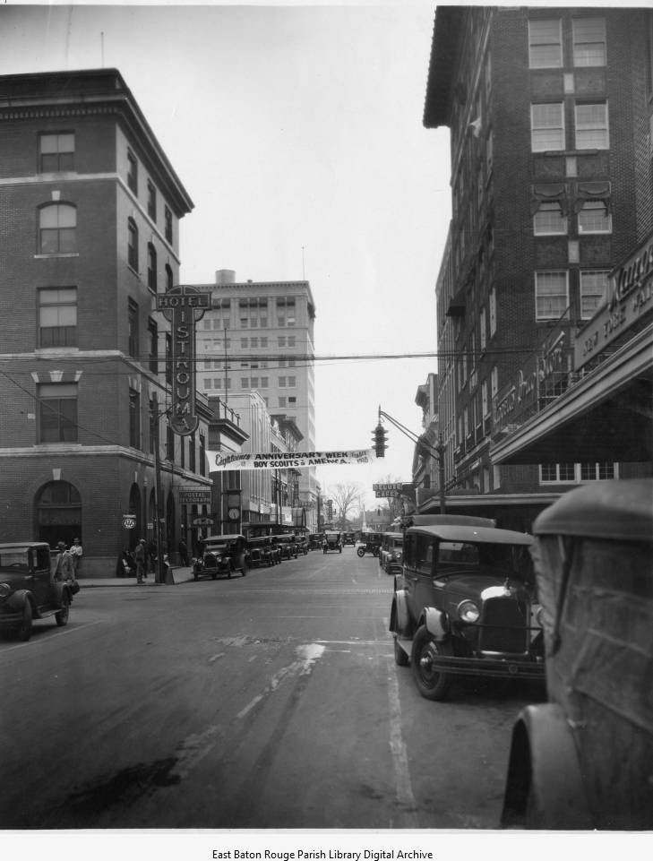
Shortly after the opening of Standard Oil, residential development expanded beyond Beauregard and Spanish Town to the Garden District, Capital Heights, Southdowns, Ogden Park, Hundred Oaks, Old South Baton Rouge, and the neighborhoods of the Plank Road corridor. Downtown took on the commercial character of traditional downtowns with the erection of commercial and civic buildings, some of which remain to this day. In 1925 Louisiana National Bank built the city’s first modern skyscraper with 12 stories located at 150 Third Street. In 1926, Louisiana State University relocated from downtown to its present campus south of the Old South neighborhood. The move and the University’s expansion reflected the city’s rapid growth.
The Baton Rouge metropolitan area is comprised of nine parishes with a total population of over 830,000 per the U.S. Census’s 2017 estimate, making metropolitan Baton Rouge the nation’s 71st largest metropolitan statistical area.
In 1932 construction finished on a new state capitol. The structure immediately marked the city’s skyline and was a testament to the vision of Governor Huey P. Long. It was then and remains the tallest state capitol in the nation. A year later four separate donors gave LSU a tupelo cypress swamp next to campus. They stipulated that LSU turn the swamps into lakes and parks for public use. The LSU lakes were created by hundreds of men employed by the Works Progress Administration, a federal agency created during the Great Depression. They were adjacent to the City Park Golf Course which was built in 1926 as the community’s first municipal golf course and is one of 20 courses in the country to be placed on the National Register of Historic Places.
.
As the city approached the middle of the twentieth century, it matured into a mid-sized city with a defined urban character, infrastructure, society and national profile. Baton Rouge’s population grew more than 340% between 1940 and 1956. During World War II Baton Rouge’s petrochemical plants benefited from increased wartime production. The city’s identity matured during these years as well. The Goudchaux downtown department store opened in the late 1930’s and quickly became a retail icon locally and nationally. The Belmont Hotel opened in 1946 at the intersection of Airline Highway and Greenwell Springs Road. In the decades after its 1946 opening Carey Grant and Jane Fonda were guests and its convention facilities were frequent venues for the city’s society scene. Because of segregation, Black celebrities visited the Lincoln Hotel which opened in 1955 on Eddie Robinson Drive. Visitors included James Brown, Aretha Franklin, B.B. King, and Nat King Cole.
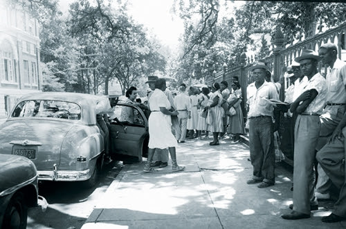
In 1949 voters approved the creation of a consolidated government that would pursue a regional approach to governance, planning, and development. The aspirations for a unified government were noble, but Baton Rouge – like all of the South – was a Jim Crow city, and the city’s black residents had long organized to fight for equality. Those struggles had national significance and foreshadowed many of the city’s future urban development challenges. The city’s 1953 bus boycott served as a model for the historic Montgomery Bus Boycott, which led to the emergence of a young leader, Rev. Dr. Martin Luther King, Jr. When the city’s school system refused to integrate its public schools after the Supreme Court’s 1954 decision in Brown v. Board of Education, a lawsuit was filed that would become one of the longest school desegregation battles in the nation and a significant driver of the city’s urban development.
By the 1950’s the city had developed past Airline Highway as the first period of intra-parish suburbanization unfolded, primarily on its northern and eastern edges. Neighborhoods like Broadmoor, Glen Oaks, Southern Heights, Westdale Heights, and Southdowns offered Baton Rougeans both modest and large ranch homes on spacious tree-covered lots and quiet cul-de-sac streets. Upscale developments along Jefferson Highway, including Goodwood, Bocage and Jefferson Terrace catered to the region’s wealthy elite. As Baton Rouge’s low-density urban form spread, developers planned for car-oriented strip-mall shopping centers. Following the 1953 opening of the Westmoreland Shopping Center at the corner of Government Street and Acadian Thruway, the Delmont Village Shopping Center opened at the corner of Plank and Lorraine Street in 1955. The city’s first mall, Bon Marche, opened in 1960 on Florida Boulevard, the burgeoning retail strip of the era.
The interstate development greatly impacted development patterns in Baton Rouge and, as was the case in virtually every other metropolitan area, set the stage for suburban sprawl.
 The passage of President Dwight D. Eisenhower’s Federal-Aid Highway Act of 1956 led to the creation of over 41,000 miles of highways and marked a new chapter in the nation’s urban development. Baton Rouge was connected to the state’s network of highways with U.S. 190, Airline Highway, which linked the city with southwestern Louisiana and New Orleans. U.S. 190 entered the city across the Huey P. Long-Oscar Allen Bridge, which opened in 1940. By the mid-1950s plans were underway for another bridge that would connect Baton Rouge with a new national highway system.
The northern route of Baton Rouge’s interstate system began downtown with an independent freeway known as the Baton Rouge Expressway that opened in 1957. The first section extended roughly one mile between Spanish Town Road and Plank Road and comprised what is known today as Interstate 110. Interstates 10 and 12 were planned in the 1950’s and added to the national highway system in 1957. Construction of the expanded interstate system began in the 1960’s and the Horace Wilkinson Bridge opened in 1968, bringing I-10 across the river just south of downtown. Interstate construction continued until the mid-1970s, by which time the city had stretched out along I-12 and was beginning to grow along I-10 towards New Orleans.
The interstate development greatly impacted development patterns in Baton Rouge and, as was the case in virtually every other metropolitan area, set the stage for suburban sprawl. Interstate construction cut almost exclusively through the city’s Black neighborhoods, literally splitting the Old South and Valley Park neighborhoods down the middle. Across the nation interstate development targeted Black neighborhoods as a way to effect “slum clearance” and remove Black residents from valuable land in and near downtowns. The highway systems also offered White suburban residents easy access to employment and commerce downtown and the new bedroom communities developing on the edge of town. “White flight,” as it was termed, characterized a new phase of residential racial segregation subsidized and facilitated by an unprecedented level of federal spending and national policy. In the decades that followed the impact of these policies reshaped the shape of American metropolitan regions, and Baton Rouge was no exception.
As interstate construction came to an end in the mid-1970s, Baton Rouge was benefiting from the 1970’s oil boom. In the late 1960’s and early 1970’s downtown Baton Rouge saw the construction of the 21-story Chase Bank building between Florida and Laurel Streets and the 24-story One American Place building between Main and North Streets. Both buildings changed the city’s skyline. But downtown declined in the 1970’s as strip shopping center and mall development drew retail activity away from downtown.
Corporate Mall opened in 1974 at the intersection of Corporate Boulevard and College Drive next to a 22-story Hilton Hotel that opened in 1976 and previewed a wave of multi-story hotel development in the area over the following decades. In 1976 Cortana Mall opened at the intersection of Airline Highway and Florida Boulevard, at that time still the urban fringe. It featured 1.2 million square feet of space, making it the largest shopping mall in the south and the 14th largest in the nation at that time. In the late 1970s home buyers were settling in large ranch home-dominated neighborhoods such as Sherwood Forest, Villa Del Rey, Park Forest, Monticello, and the neighborhoods of the rapidly growing Perkins Road corridor, including Concord Estates, Stratford Place, Pollard Estates, Kenilworth, Mayfair, and Magnolia Woods.
The city’s school desegregation fight continued into the 1980s, and in 1981 forced busing was mandated by the federal courts, resulting in waves of white and middle class flight out of the public school system and out of Baton Rouge. 7,000 white students moved from public to private schools in 1981 alone. School desegregation had an undeniable imprint on the city’s urban development.
After a decade of downtown office tower and suburban mall construction, Baton Rouge suffered as the oil bust impacted development in the 1980’s. By the mid-1980’s downtown Baton Rouge was suffering the same cycles of urban blight affecting downtown’s across the nation. A plan to revitalize the city’s downtown warehouse district resulted in the opening of Catfish Town in 1984, a $28 million festival marketplace that opened with great fanfare but was shuddered less than two years later. The legalization of riverboard gambling in the early 1990s resulted in two gaming establishments in downtown Baton Rouge and the slow revival of the area’s nightlife.
 The city’s school desegregation fight continued into the 1980s, and in 1981 forced busing was mandated by the federal courts, resulting in waves of white and middle class flight out of the public school system and out of Baton Rouge. 7,000 white students moved from public to private schools in 1981 alone. School desegregation had an undeniable imprint on the city’s urban development. Population migrated outward along I-12 and I-10, and a new suburban identity emerged in the increasingly upscale neighborhoods of South Baton Rouge.
The improved national economy of the mid-to-late 1990’s resulted in a new wave of home construction in Baton Rouge, and new neighborhoods opened even further down Perkins Road as Bluebonnet Road, Siegen Lane, and Highland Road became new population centers. In 1997 The Mall of Louisiana opened on Bluebonnet Drive near the Jimmy Swaggert Bible College, becoming the largest mall in Louisiana. The mid-scale, contemporary mall signaled a dramatic shift from the Airline/Florida urban growth of mid-century Baton Rouge to the 21st century prominence of the new South Baton Rouge.
When the school desegregation case was finally settled in 2003, the East Baton Rouge Parish School System served a majority black and poor population. Significant growth and development was occurring in Livingston and Ascension parishes. Population growth in neighboring parishes and in the growing East Baton Rouge Parish cities of Zachary and Central reflected both the long backlash to school desegregation in Baton Rouge public schools and the emerging metropolitan character of the Baton Rouge region. By the turn of the century the city was much more aware of this metropolitanization and launched planning efforts to revitalize downtown, which was still desolate and blighted. The first decade of the 21st century saw downtown revitalization take off with the consolidation of state government into several new office buildings, the Shaw Center for the Arts, the North Boulevard Town Square, the revival of the 1927-built Hiedelberg Hotel, and the construction of a state of the art courthouse for Louisiana’s 19th Judicial District.
The city’s population swelled in 2005 after Hurricane Katrina, but the city was already experiencing steady growth when the storm struck. The traffic gridlock after the storm marshalled a political response that resulted in the first major road construction program for East Baton Rouge Parish in over 60 years. The “Green Light” program not only increased the capacity of urban roads, it improved connectivity and made significant improvements in the city’s disjointed street grid. While road construction impacted the entire parish, roads like south Baton Rouge’s Siegen Lane experienced dramatic transformations that increased automobile throughput, but often without any meaningful provisions for pedestrians or mass transit. The access challenges for anyone without a car underscored a bigger problem: Baton Rouge had become a “tale of two cities” with stark disparities between the parish’s more affluent and developing southern side and its abandoned, blighted northern side. “North Baton Rouge” became synonymous with concentrated black poverty, urban blight, and dangerous crime.
Baton Rouge celebrated its 200th anniversary in 2017 and today is the center of the nation’s 71st largest metropolitan area.
The early decades of the 21st century saw South Baton Rouge’s affluent identity reflected in an explosion of luxury home development along Highland Road and in neighborhoods like Santa Maria, University Club, Willow Grove, and Bocage Lakes.The Perkins corridor continued to densify as developments like Perkins Rowe added a new experiential and decidedly upscale dimension to the city’s shopping. During the same period the neighborhoods of North Baton Rouge experienced rapid disinvestment, a trend that had been taking place since school desegregation and intensified after the turn of the century.
If the big-box shopping centers of Siegen Lane were emblematic of South Baton Rouge’s commercial boom, the vacant and blighted storefronts of Plank Road were emblematic of North Baton Rouge’s rapid demise. In 2013 Earl K. Long hospital closed its Airline Highway location, a staple in the area since the early 1960’s and the only emergency room for miles. The closure became a rallying cry for community activists across the city who worried about continued disinvestment and a neglected North Baton Rouge. Across town, a petition drive to form a new city out of the southern, unincorporated areas of East Baton Rouge Parish began in 2015. The initial effort fell short but a second effort in 2019 was successful and voters in the area proposed for incorporation approved the petition to create the new city of St. George. The matter is currently in litigation.
The north-south divide and its racial implications were magnified in the July 2016 shooting of Alton Sterling, which was followed by the ambush and murder of three Baton Rouge police officers. The internationally-covered event gave rise to discussions about the impact of racial and spatial stratification not only on the bonds of community, but on the city’s economic development competitiveness. A month later and as these conversations were growing, Baton Rouge was hit with record flooding that impacted over 70,000 structures in the metropolitan region. The back to back strategies placed an international spotlight on the city and elevated the community’s focus on resiliency. Flood recovery continues and conversations about the perils of racial and spatial stratification for the city’s identity, economic fortunes and general appeal are ongoing.
Baton Rouge celebrated its 200th anniversary in 2017 and today is the center of the nation’s 71st largest metropolitan area. Recent efforts focused on reviving Mid-City neighborhoods, turning the tide of disinvestment in North Baton Rouge, a major widening of I-10, and an overhaul of the City-Park/LSU Lakes underscore the ever-evolving nature of the city’s built environment. New voices are advancing conversations about racial equity, transit-oriented development, and climate change. These conversations are already shaping new urban development pursuits and will undoubtedly influence the shape of the city in the years ahead.